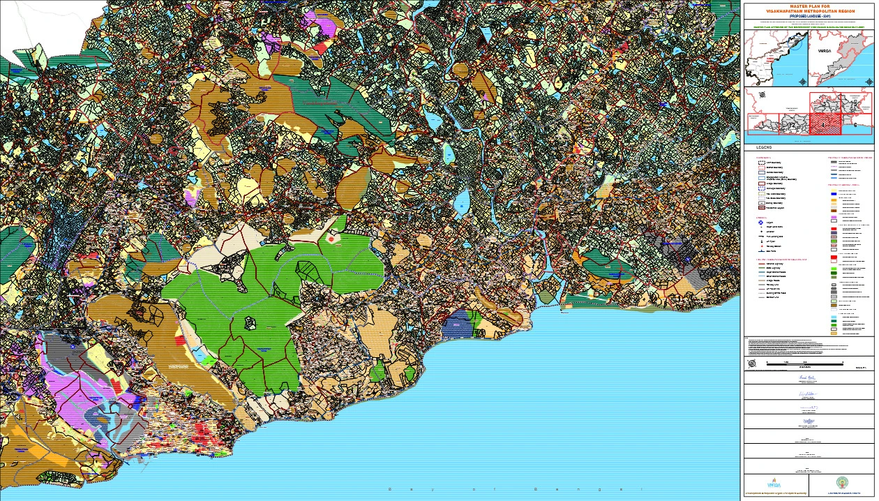
VMR Master Plan 2041 PDF Map of Visakhpatnam Metropolitan Region (Proposed Landuse)
Visakhapatnam Metropolitan Region (VMR) Master Plan 2041 is one of the most important planning documents prepared for the future development of Visakhapatnam and its surrounding areas. Prepared in line with the Perspective Plan 2051, this Master Plan aims to guide urban growth, improve infrastructure, protect the environment, and create opportunities for sustainable development across the entire region.
VMRDA Master Plan 2041
VMRDA Master Plan (2041) is a statutory blueprint prepared under the AP Metropolitan Region and Urban Development Authorities Act, 2016 (APMR & UDA Act, 2016
It covers various aspects such as:It covers various aspects such as:
- Land use classification
- Road network and transport corridors
- Infrastructure development
- Environmental protection
- Waterbody buffers
- Conservation of forest and hill areas
- Zoning regulations
- Village and urban growth management
Features of the VMR Master Plan (2041)
- Prepared in Line with Vision 2051The Master Plan is derived from a long-term Perspective Plan (2051), ensuring smooth continuity of development for the next several decades.
- “Proposed Land Use” OnlyThe land use shown in the plan is only a proposed category. It does not:
- confirm land ownership
- serve as a legal proof for property disputes
For any land-related issue, the Revenue Department’s records are final.
- Accurate Mapping with GIS TechnologyThe Master Plan uses modern GIS mapping to integrate:
- cadastral/survey data
- natural features
- urban boundaries
- transport networks
However, in case of mismatch, ground-level and revenue records will be treated as final.
- Protection of WaterbodiesAll buffers around rivers, lakes, ponds, streams, canals, and tanks will follow:
- AP Building Rules
- AP Land Development (Layout) Rules
- Subsequent amendments
This ensures ecological balance and prevents illegal encroachments.
- Clear Rules for Forest and Hill AreasIf there is any confusion regarding boundaries of:
- forest land
- hills
- eco-sensitive zones
the records of the Forest Department and Revenue Department will be considered final.
- Transport Network DevelopmentThe Master Plan includes detailed proposals for:
- highways
- arterial roads
- metro rail
- metrolite and tram corridors
- BRTS routes
- railway expansions
Actual alignments may change based on final engineering design.
- Guidelines for Existing & Proposed RoadsExisting roads shown are indicative, and their right-of-way will depend on field conditions during permission processing.
- Compliance With CRZ RulesAs Visakhapatnam has a long coastline, CRZ regulations will apply wherever required. Projects must comply with the latest CRZ Management Plan (CRZMP).
- Inclusion of Eco-sensitive ZonesImportant areas like Kambalakonda Reserve Forest Eco-Sensitive Zone are marked as per official Gazette notifications to ensure protection and controlled development.
- Must be Read With Zoning RegulationsThe Master Plan must be interpreted along with the Zoning & Development Promotion Regulations (ZDPR), which explain:
- permissible activities
- building norms
- development controls
- land use conversion rules