APCRDA Detailed Master Plan of Capital City Amaravati PDF Map
The Andhra Pradesh Capital Region Development Authority (APCRDA) has designed a comprehensive Detailed Master Plan for Amaravati, envisioning it as a globally competitive and sustainable capital city. The plan integrates economic growth, infrastructure development, and environmental sustainability to transform Amaravati into a dynamic urban hub.
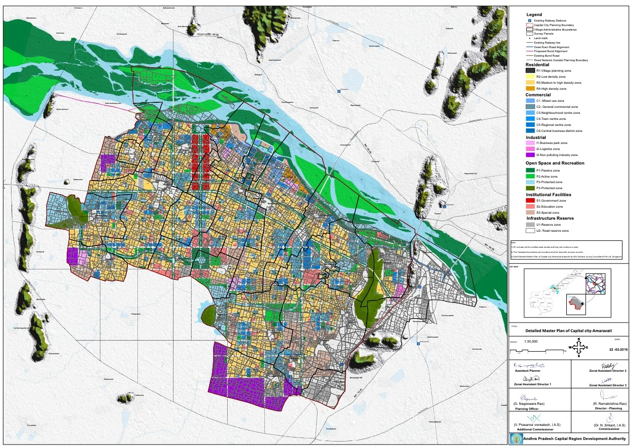
Features of the Amaravati Master Plan
The Amaravati Master Plan has been meticulously crafted with specific land use and zoning strategies. Some of its key highlights include:
- Land Use Zoning
- The plan categorizes land use into different zones to ensure balanced and systematic urban development.
- Residential Zones (R1, R2, R3, R4) – Low, medium, and high-density residential areas.
- Commercial Zones (C1 to C6) – Mixed-use, general, and central business districts.
- Industrial Zones (I1, I2, I3) – Business parks, logistics hubs, and non-polluting industries.
- Institutional Zones (S1, S2, S3) – Government buildings, education centers, and specialized zones.
- Open Space & Recreation (P1, P2, P3) – Parks, protected areas, and green buffers.
- Infrastructure Development
- Expressways & Road Networks – Integration with NH-16, NH-65, and Vijayawada Bypass.
- Public Transport – Metro corridors, bus rapid transit (BRT), and pedestrian pathways.
- Riverfront Development – Planned river promenades along the Krishna River.
- Economic & Industrial Development
- Central Business District (CBD) – Commercial and financial hubs.
- Special Economic Zones (SEZs) – Designed to attract industries and global investments.
- Knowledge & Education Hubs – Universities and research institutions integrated with industry.
- Sustainability & Environmental Protection
- Green Building Initiatives – Encouraging eco-friendly urban development.
- Water Conservation – Protection of notified water bodies and efficient stormwater management.
- Renewable Energy – Focus on solar and wind power integration.
CRDA Amaravati Master Plan Highlights
| Feature | Details |
|---|---|
| Total Area | 217 sq. km |
| Major Roads | NH-16, NH-65, Inner Ring Road |
| Residential Density | Low to high-density housing |
| Commercial Centers | CBD, town centers, mixed-use zones |
| Industrial Zones | Business parks, logistics, and SEZs |
| Transport | Metro, BRT, expressways |
| Green Spaces | Riverfront promenades, parks, open spaces |
| Environmental Focus | Sustainable energy, water conservation |