Hathras (Mahamayanagar) Master Plan Regulated Area Map PDF 2021
The Hathras (Mahamayanagar) Master Plan is a comprehensive urban development roadmap that ensures sustainable growth, improved infrastructure, and balanced urban expansion. By implementing structured land use planning, transportation enhancements, and environmental sustainability measures, the plan aims to transform Hathras into a modern, well-connected, and livable city while preserving its rich heritage and economic potential.
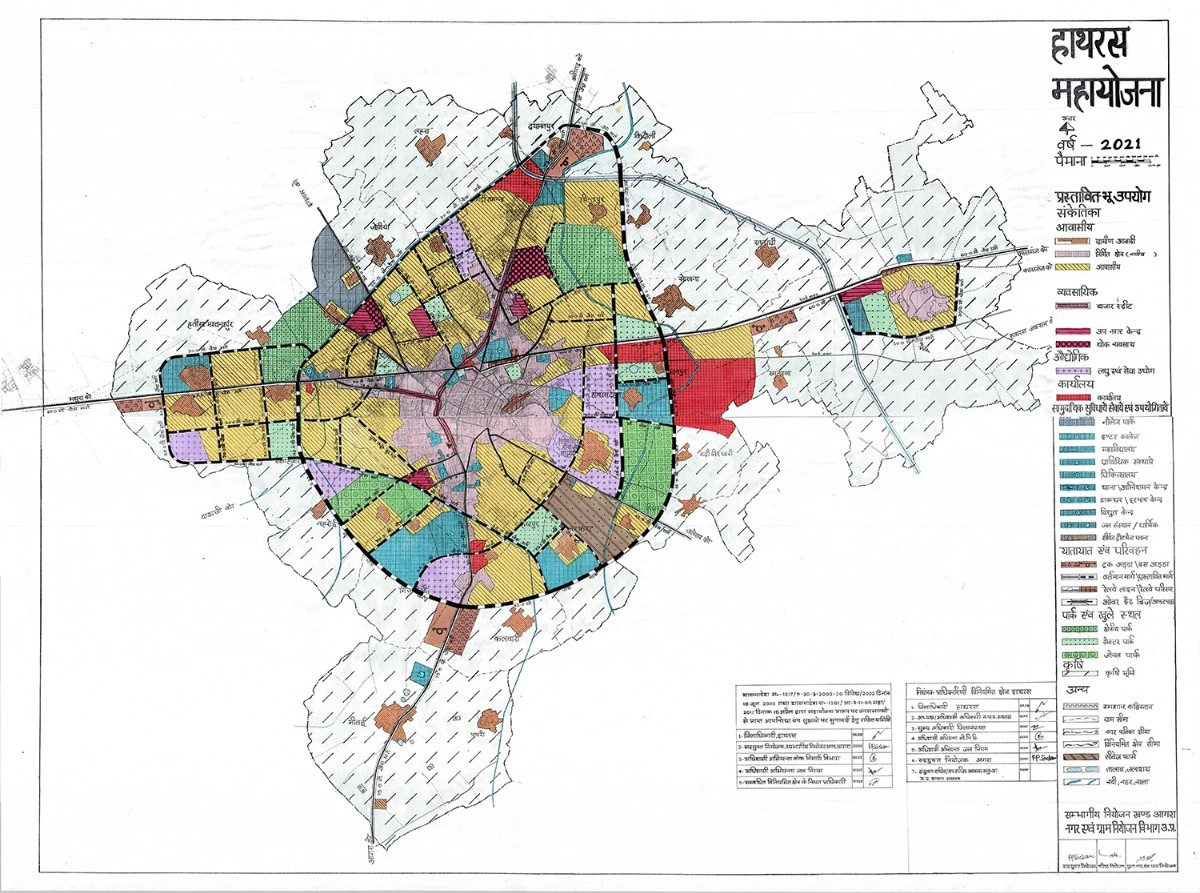
The Hathras Master Plan pdf map 2021 provides detailed insights into zoning regulations, road networks, and infrastructure development. You can download the official Hathras Master Plan Regulated Area Map PDF from UP government portals or link given below.
Hathras (Mahamayanagar) Regulated Area Map & Urban Development
Hathras, also known as Mahamayanagar, is an important town in Uttar Pradesh known for its historical significance, industrial activities, and agricultural trade. To ensure planned urban development, the Hathras Master Plan has been designed to regulate land use, improve infrastructure, and accommodate future growth.
The Hathras Regulated Area was declared under the Uttar Pradesh Regulation of Building Operations Act, 1958, aiming to control unplanned construction, manage urban sprawl, and provide better civic amenities. The Hathras Master Plan Regulated Area Map provides a detailed land use plan, ensuring sustainable and structured urban development.
Features of Hathras Master Plan
- Land Use Zoning
The Hathras Master Plan categorizes land into specific zones to ensure balanced development:
- Residential Zones – Planned housing sectors with modern amenities.
- Commercial Zones – Business centers, shopping complexes, and wholesale markets.
- Industrial Zones – Dedicated areas for agro-based industries, small-scale manufacturing, and warehouses.
- Institutional Zones – Schools, colleges, hospitals, and government offices.
- Green & Open Spaces – Parks, gardens, and eco-sensitive zones.
- Road & Transport Connectivity
The Hathras Master Plan focuses on improving regional connectivity and urban mobility:
- Widening of major highways to enhance connectivity with Agra, Aligarh, and Mathura.
- Expansion of local roads and bypass routes to decongest traffic.
- Upgradation of public transport facilities, including bus stands and railway stations.
- Integration with major highways, including NH-93 (Aligarh-Kanpur Highway) for better logistics and trade movement.
- Industrial & Economic Development
Hathras has a strong industrial base, especially in agriculture, dairy, textile, and handicrafts. The master plan promotes:
- Development of agro-based industries to support the local economy.
- Expansion of industrial areas for small and medium enterprises (SMEs).
- Encouragement of local businesses by setting up wholesale trade hubs and logistics parks.
- Public Infrastructure & Urban Facilities
To improve the quality of life, the Hathras Master Plan focuses on:
- Modernization of hospitals, educational institutions, and administrative buildings.
- Development of community centers, stadiums, and recreational zones.
- Implementation of smart city solutions for waste management, water supply, and sewage treatment.
- Environmental Sustainability & Heritage Conservation
Expansion of green belts and plantation drives to maintain environmental balance.
- Pollution control measures for industries and urban settlements.
- Preservation of historical sites and temples to boost tourism.