Bareilly Master Plan PDF Map 2021
The Bareilly Master Plan 2021 aims to transform the city into a well-planned, modern urban center with a sustainable infrastructure and balanced growth. By ensuring efficient land use, improved connectivity, enhanced public services, and environmental conservation, the plan envisions a better quality of life for residents while preserving Bareilly’s cultural and economic heritage.
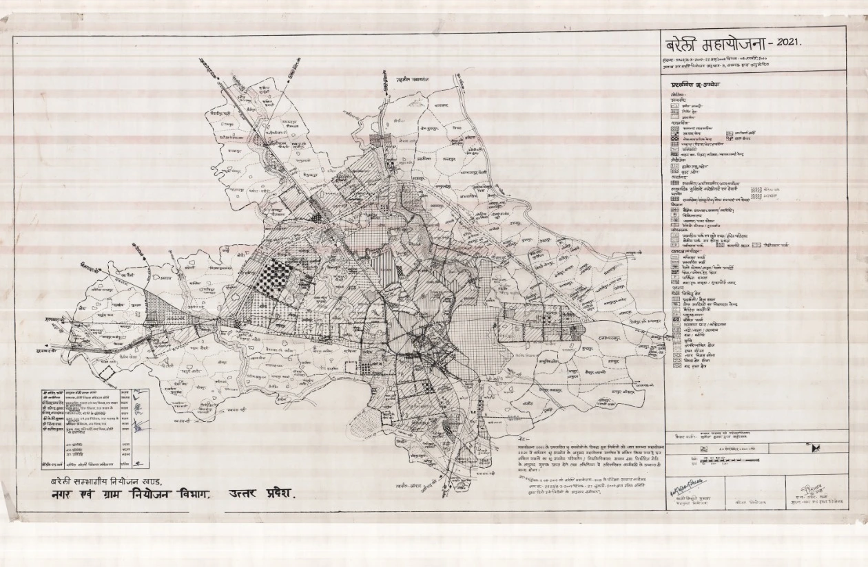
Bareilly Master Plan – Development Map, Land Use & Urban Planning
Bareilly, a major city in Uttar Pradesh, serves as an administrative and commercial hub. Known as “Bans Bareilly” and “Nath Nagri,” the city has a rich cultural heritage and is strategically located on the Ramganga River. It is well-connected by NH-24, NH-74, SH-33, and SH-37, linking it with major cities like Lucknow, Pilibhit, Aligarh, and Kathgodam.
To manage rapid urban expansion and ensure planned development, the Government of Uttar Pradesh declared Bareilly as a Regulated Area in 1971 under Order No. 4190-K/37-89 N.K.V. 71, covering Nagar Palika areas and 198 adjoining villages. In 1977, it was further classified as the Bareilly Development Area under Order No. 1030/37-2-72 D.A./76. The Bareilly Master Plan 2021, based on a projected population of 14.21 lakh, was approved under Government Order No. 5962/8-3-2009-22 maha/2008 dated 08th January 2010.
Features of the Bareilly Master Plan 2021
- Residential Development
- Expansion of planned housing sectors to accommodate the growing population.
- Development of affordable housing schemes for low and middle-income groups.
- Modern urban infrastructure, including water supply, sewage, and electricity networks.
- Redevelopment of older residential areas to enhance living conditions.
- Industrial & Economic Growth
- Promotion of Bareilly’s trade and commercial hubs to boost economic activities.
- Encouragement of small-scale industries, agro-based industries, and handicrafts.
- Establishment of special economic zones (SEZs) to attract investments.
- Development of warehousing and logistics hubs for better supply chain management.
- Road & Transport Connectivity
- Expansion and widening of NH-24 and NH-74 for better intercity travel.
- Development of bypass roads and flyovers to reduce congestion.
- Strengthening of public transport infrastructure, including new bus terminals and railway station upgrades.
- Introduction of dedicated pedestrian zones and cycling tracks to promote sustainable mobility.
- Public Infrastructure & Urban Facilities
- Establishment of new hospitals, schools, and technical institutes.
- Development of police stations, fire stations, and government offices for improved public services.
- Construction of sports complexes, community centers, and cultural hubs to enhance social engagement.
- Implementation of solid waste management and sanitation projects to maintain cleanliness.
- Environmental & Sustainable Development
- Expansion of green belts, urban parks, and eco-sensitive zones.
- Implementation of rainwater harvesting and water conservation projects.
- Strict pollution control measures to improve air and water quality.
- Preservation of natural landscapes and heritage sites to boost tourism.