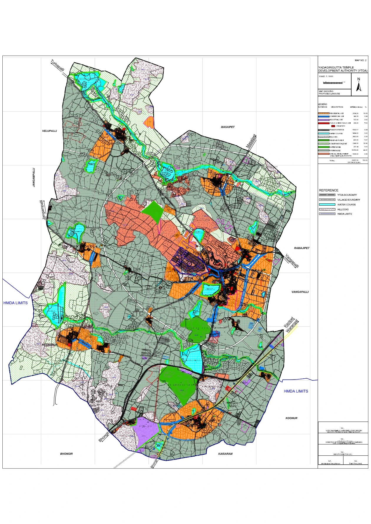
YTDA Master Plan PDF Map
The YTDA Master Plan is a transformative initiative that will elevate Yadagirigutta’s status as a spiritual and cultural hub while ensuring sustainable urban development. With improved connectivity, eco-friendly infrastructure, and enhanced pilgrimage facilities, Yadagirigutta is set to become a major religious tourism destination in Telangana.
Features of the YTDA Master Plan
- Temple Complex Development
- Temple City (Phase I & II) covering 848.13 acres for religious and tourism infrastructure.
- Forest Area of 87.06 acres to preserve biodiversity.
- Gandi Cheruvu (34.07 acres) designated for water conservation and beautification.
- VVIP Cottages, Kalyana Mandapam & Pilgrim Accommodations for visitor convenience.
- Tourism & Cultural Development
- Establishment of a premier temple tourism hub with connectivity to:
- Warangal Heritage Temples
- Bhongir Fort
- Pembarthi Crafts Village
- Kolanpaka Jain Temple
- Development of state-level, regional, and local cultural circuits.
- Establishment of a premier temple tourism hub with connectivity to:
- Population & Demographics
- Projected Population for 2035: 1.26 lakh
- Floating Population: Nearly 1 lakh pilgrims and tourists expected daily.
- Temple Service Population: Workers and administrators residing within the temple town.
- Road & Transport Infrastructure
- National Highway (NH-163) widened to 60m for better connectivity.
- Outer Ring Road (50m wide) for smoother traffic flow.
- New MMTS railway station at Raigiri and a high-speed metro connecting to Hyderabad.
- Urban Expansion & Land Use
- Planned urban expansion with designated zones:
- Residential: 2,557 acres
- Commercial: 242 acres
- Industrial: 162 acres
- Public & Semi-Public Facilities: 288 acres
- Transportation & Roads: 1,560 acres
- Conservation Zones & Green Belts: 3,339 acres
- Planned urban expansion with designated zones:
- Environmental Sustainability
- Dense plantation and green corridors to maintain ecological balance.
- Rainwater harvesting and sewage treatment plants for water management.
- Restricted development in eco-sensitive areas, including the Hillock region.
Highlights of YTDA Master Plan
Feature | Details |
---|---|
Total Area Covered | 104.58 sq. km |
Temple Complex Expansion | 1,391 acres |
Planned Road Network | NH-163 expansion, 50m ORR |
Tourism Development | Cultural circuits, Bhongir Fort, Warangal Temples |
Projected Population (2035) | 1.26 lakh |
Sustainability Measures | Rainwater harvesting, forest conservation |
Public Transport Upgrades | Raigiri railway station, MMTS, Metro link |