Bharatna Etawah Master Plan / Regulated Area Map PDF 1991
The Bharthana Master Plan envisions a structured and sustainable urban expansion model, ensuring planned growth, enhanced infrastructure, and economic prosperity. By focusing on agricultural and industrial development, improving public amenities, and strengthening transportation, Bharthana is set to emerge as a modern, well-equipped city while preserving its rich agricultural and cultural heritage.
Features of Bharthana Master Plan Uttar Pradesh
| Category | Details |
|---|---|
| Residential Development | – Expansion of planned housing sectors to accommodate the growing population. – Development of affordable housing for low and middle-income groups. – Creation of well-structured colonies with access to basic urban amenities. |
| Industrial & Economic Growth | – Promotion of agro-based industries due to the region’s fertile land and agricultural dominance. – Encouragement of small-scale industries to boost local employment. – Expansion of business hubs and commercial centers to enhance trade and services. |
| Road & Transport Connectivity | – Strengthening the Bakewar-Mainpuri State Highway for better regional connectivity. – Improved railway infrastructure due to Bharthana’s location on the Kanpur-Delhi railway route. – Development of bypass roads and transport hubs to reduce congestion. |
| Public Infrastructure & Urban Facilities | – Establishment of schools, hospitals, and public health centers for better civic services. – Development of law enforcement facilities including police stations and fire stations. – Construction of sports complexes, community centers, and recreational areas. |
| Environmental Sustainability | – Implementation of solid waste management and sewage treatment to ensure a clean environment. – Designation of green belts, parks, and eco-sensitive zones for a balanced ecosystem. – Promotion of water conservation projects to maintain groundwater levels. |
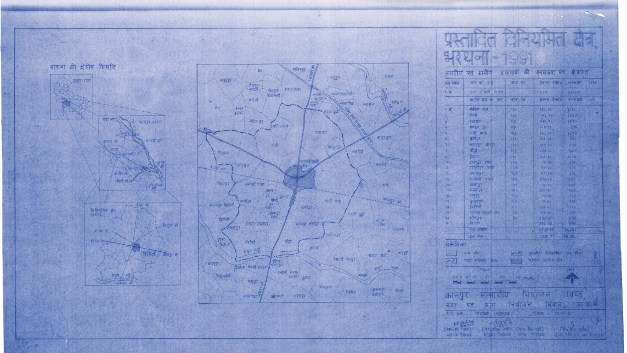
Bharthana Regulated Area – A Step Towards Planned Urban Growth
The Bharthana Regulated Area was officially designated through Notification No. 1360/9-A-3-92-6 R.A./92 issued by the Government of Uttar Pradesh on July 30, 1992. This notification was aimed at preventing unplanned development, checking the rise of low-standard colonies, and ensuring systematic urban expansion.
A total of 21 villages from Bharthana Municipality and Bharthana Tehsil were included within the regulated area, covering an expansive land area of 7330.77 hectares. The Bharthana Municipality, as per the 2011 Census, recorded a population of 44,120 people and spanned an area of 600 hectares.
The inclusion of these villages under the Regulated Area Plan was a proactive measure to control haphazard construction, improve living standards, and facilitate sustainable urban growth.
List of Villages Included in Bharthana Regulated Area
Below is the list of 21 villages included in the Bharthana Regulated Area:
- Gopiyaganj
- Bholi
- Ramaayan
- Mahmoodpur
- Pali Kala
- Sujipur
- Sahajpur, Gyanpur
- Bhodhee
- Kubra
- Turakpur Pachar
- Pipripur Pachar
- Asafpur
- Kandhesi Pachar
- Hajipur
- Samaspur
- Rampur
- Kutubpur
- Biroudhee
- Bharthana Dehat Area
- Seehpura
- Ninava