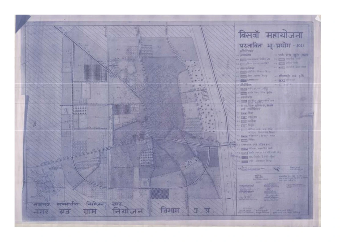
Biswan(Sitapur) Master Plan Regulated Area Map PDF
The Biswan Master Plan-2021 is a strategic urban planning initiative aimed at sustainable development and organized urbanization. With improvements in infrastructure, industry, transport, and environmental conservation, Biswan is set to become a modern, well-planned city that meets the growing demands of its residents and businesses.
Features of Biswan Master Plan-2021
| Category | Details |
|---|---|
| Residential Development | Expansion of planned housing sectors to support the growing population. Development of affordable housing schemes for low and middle-income groups. Infrastructure improvement, including water supply, sewage, and electricity networks. |
| Road & Transport Connectivity | Widening of major roads (Sitapur Road, Laharpur Road, Sidhauli Road, Jahangirabad Road) to handle regional traffic. Strengthening public transport infrastructure for better mobility. Improved connectivity to Sitapur, Lucknow, and nearby towns via railway and highways. |
| Industrial & Economic Growth | Development of business hubs to support trade and small-scale industries. Encouragement of sugar mills and carpet industry to boost local employment. Establishment of wholesale markets and commercial centers. |
| Public Infrastructure & Social Services | Construction of new schools, hospitals, and public health centers. Development of law enforcement facilities, including police stations and fire stations. Expansion of sanitation, drainage, and solid waste management systems. |
| Environmental & Sustainable Development | Establishment of green belts, parks, and eco-sensitive zones for a cleaner environment. Implementation of rainwater harvesting and water conservation projects. Strict pollution control measures to maintain environmental balance. |
About Biswan, Sitapur
Biswan is an important town in the Sitapur district of Uttar Pradesh, located at 27°49′ N latitude and 81°00′ E longitude. It serves as the Tehsil headquarters and plays a significant role in regional administration and economic activities. The town is well-connected via State Highway 26 and the Sitapur-Budhwal railway line, facilitating easy access to Sitapur (34 km away) and Lucknow (83 km away).
Geographical & Climatic Overview
- Elevation: 400-500 feet above mean sea level
- Average Rainfall: 700-1200 mm annually
- Temperature Range:
- Winter: 8°C (47°F) minimum
- Summer: 46°C (115°F) maximum
Declaration of Regulated Area & Master Plan Approval
To control unplanned urban expansion, the Government of Uttar Pradesh declared Biswan Town as a regulated area under the U.P. (RBO) Act, 1958, through G.O. No. 200/37-3-87-6R.A.-86, dated May 1, 1987.
The Biswan Master Plan-2021 was later approved on August 8, 2001, via G.O. No. 765/9-आ-3-2001-5 महा0/2000, covering Biswan Nagar Palika and 14 adjacent villages for planned urban development.
List of Villages Included in Biswan Regulated Area
The Biswan Master Plan covers the following 14 villages:
- कामयाबपुर (Kamayabpur)
- गुरैरा (Guraira)
- सरैया माफी (Saraiya Mafi)
- भगवानपुर माफी (Bhagwanpur Mafi)
- महमूदपुर (Mahmoodpur)
- जलालपुर (Jalalpur)
- पुरैनी (Puraini)
- अशरफपुर (Ashrafpur)
- अमर नगर (Amar Nagar)
- खांझर (Khanjhar)
- सरैया मिर्जापुर (Saraiya Mirzapur)
- करीम पनाह (Karim Panah)
- बेनीपुर (Benipur)
- बिसवा (Biswan)